In The Beginning
The land that would eventually become the East Morrissey neighborhood began as part of Branciforte Township. The settlement of Branciforte was originally established in 1797 by the Spanish in an effort to protect their colonies from other powers, including the Russians and the English. Convincing settlers to come to the area proved difficult. Despite “circulares” sent throughout New Spain (now Mexico) promising colonists an adobe house, all necessary farm implements, and yearly monies, the Spanish were only able to obtain 8 prospective settlers to come to Branciforte, most of whom were petty criminals. It should be noted that when the settlers arrived, they found none of the items they had been promised and the settlement struggled to survive (1).
Another, more successful, method of encouraging settlement was offering retiring Spanish soldiers, called “Invalidos,” pensions and land grants if they settled in Branciforte. These men had completed a 10 year military commitment and remained subject to call for further duty, thus providing a natural fighting force ready to defend the coast (2). Amongst this group was Miguel Villagrana.
Miguel Villagrana was born in Tepic, New Spain, in approximately 1779. Villagrana’s first appearance in Branciforte records was in 1824, when he and his wife, Francisca, baptized their son, Miguel Sontero Villagrana at the Santa Cruz Mission. Villagrana’s high standing in the community was evidenced by his holding the position of Regidor in 1832 and Alcalde in 1836. Alcalde was the title given to the head local official, elected by popular vote, and Regidor was his assistant. According to local records, after being elected Alcalde, it was discovered that Villagrana couldn’t read or write. This triggered a “gentle civil war” in the village and he was removed from his post (4).
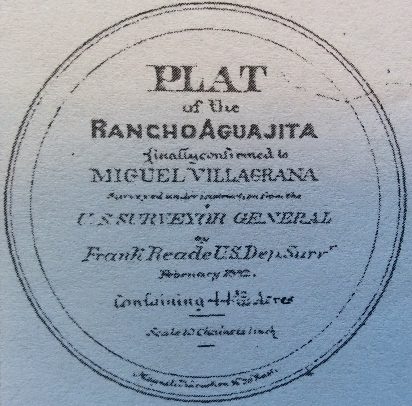
Most interesting for our purposes, on November 20, 1837, Miguel Villagrana received a land grant from Governor Alvarado for a parcel then known as “Rancho Aguajita” (5). The ranch, the smallest of the land grants given, was only 500 varas (40 acres). The land was located just outside what is now the eastern boundary of the Santa Cruz city limits, later known as Arana Gulch, and now the current site of Harbor High School (6)
Map by Frank Reade, 1882
Rancho Aguajita was located a short distance east of where the East Morrissey neighborhood would eventually be built, just inside the city boundaries. This fact may leave the reader wonder why I have chosen to begin my story here. The reason being, the earliest map of the East Morrissey neighborhood I have uncovered, dated 1865, notes the land owner of what would eventually become the Eastern portion of the neighborhood (i.e Park Way, Suburbia Ave, Acacia Way, etc.) as Francisca Villa (7). This indeed is Miguel Villagrana’s wife. Why is her last name listed as Villa and not Villagrana? The name was shortened in public records because the English settlers had trouble with the pronounciation. Despite the change, it would continue to be misspelled at times, as Bea or Bia (8).
Santa Cruz County Book of Deeds vol 7 p. 254, circa 1865
Another early settler and neighbor of the Villagranas was William Trevethan. Trevethan was born August 18, 1803 in Plymouth, Devonshire, England. Beginning in 1822, he lived a life at sea, working on whaling ships and trading vessels. He spent time in China, New Zealand, and Hawaii, amongst other places. He was even shipwrecked for a time on Jarvis Island in the South Pacific. Trevethan arrived in San Francisco in either 1824 or 1826. Source materials differ as to the exact date. Upon arrival, he decided to remain in California and held various jobs around the Monterey Bay area, including precuring supplies for troops stationed in Monterey (9). Trevethan later moved to Santa Cruz where he married Maria Antonia Perez in 1841. Once in Santa Cruz, he again held a variety of jobs, including running a saw mill on the San Lorenzo River. In 1856, he built a farm on 66 acres adjacent to the land owned by the Villagranas, 14 acres of which he actually purchased from them directly.
Below is a link to the content of an interview William Trevethan did for the Santa Cruz Sentinel in 1870.
See the map below to better understand the part of today’s East Morrissey neighborhood that was once William Trevethan’s ranch. As you can see, the eastern boundary of his property would later be named Tevethan Lane, then Trevethan Street, and finally the Trevethan Aveunue we know today.
Map generated by Norm Potevin (16)
The Rise of LaVeaga Park
The 18th and 19th centuries saw the land that would become the East Morrissey neighborhood settled by ranchers, with limited residential growth. However, the turn of the 20th century would bring unprecedented change; indeed, the very change that would create the framework of what would become the East Morrissey neighborhood. One of the seminal figured in this transformation was Patrick Morrissey.
Patrick Morrissey was born in Waterford, Ireland, in 1836, Morrissey immigrated to New York in 1852 with his parents and siblings to escape the potato family (10). He worked in the paper business in New York before moving to California. In 1860, Morrissey came to Santa Cruz to work in a paper mill, in what is now Paradise Park (11). In 1868, he bought land west and north of the Trevethan property and it become the Morrissey Ranch.
As you can see from the map below, Patrick Morrissey’s lands extended from Soquel Ave. all the way to what is today De Laveaga Park. He is said to have raised grain (12). Patrick married Honora Phair Morrissey and the went on to have two sons, James and Patrick and one daughter, Margaret (13)
1889 Map by AJ Hatch
Patrick Morrissey’s story mirrors his neighbors in the great distances he came to make his home in Santa Cruz, as well as the eventual decision to name the street that would be built on his land after him, Morrissey Ave., now Morrissey Blvd, in his honor. How did this come about? In 1906, Patrick Morrissey divided up his holdings and this land eventually came under the control of a consortium of investors lead by John Martin, who sought to transform it into a residential development that would be named LaVeaga Park.
As previously noted, the early 1900’s brought unprecedented change to Santa Cruz, and not all of it was for the better. Most are familiar with the earthquake that struck San Francisco, April 19th, 1906. Fewer may realize that Santa Cruz took major damage from the quake, leaving it “crippled but able to function” (14). Additional calamities, unrelated to the quake, included a fire which destroyed Fred Swanton’s Neptune Casino on the Santa Cruz Boardwalk on June 22nd, 1906 as well as the stock market crash in October, 1907 (14).
Despite these events, the early 1900’s also brought an opportunity for economic growth, spurred by such events as the annexation of Branciforte by the city of Santa Cruz in 1905. Into this changing landscape stepped the aforementioned John Martin. Born in Indianapolos in 1858, he came to San Francisco in 1891 and got involved in the electrical business, becoming one of the cofounders of Pacific Gas and Electric in 1906 (14). That same year, on July 8th, Martin came to Santa Cruz and purchased the Union Traction streetcar company.
The events described above created a perfect storm. Residential growth in Santa Cruz, spurred by the annexation of Branciforte, combined with John Martin’s business savy and ownership of various services. What was the result? LaVeaga Park, a residential development along Morrissey’s former property and the surrounding lands, much of which is now the East Morrissey neighborhood. And what was rolling down the middle of what is now known as Morrissey Blvd and past the plots of land Martin was selling? The streetcars he owned.
The idea of streetcar service as a means of spurring residential growth was not a new one. It had been the recipe for economic success in many other cities around that time. Sam Bass Warner Jr, in his book “Streetcar Suburbs” describes the role of streetcars in the development of Boston, Massachusetts (15). Furthermore, the first mass transit system set up in San Francisco in 1851 was a horse and buggy system set up by land speculators.
The above information serves as a jumping off point to understanding the history of the East Morrissey neighborhood, however there are many more stories to tell. Continue to my next blog to learn the stories behind many of the street names and learn how they fit into the fabric of the history of greater Santa Cruz area.
References
1. Reader, Phil, “A HIstory of Villa de Branciforte” Santa Cruz History Journal, Issue Number 3, c 1997 Museum of Art and History, Santa Cruz CA. p. 17.
2. Rowland, Leon, Santa Cruz, The Early Years, Paper Vision Press, Santa Cruz, CA, 1980, p. 35
3. Koch, Margaret, Santa Cruz County Parade of the Past Valley Publishers, Frenso, CA 1973, p. 7
4. Wells, Evelyn, Santa Cruz: It’s Romantic History From the Coming of the Mission Fathers Nearly Three Centuries Ago to Present Times, c. 1920.
5. Rowland, Leon Santa Cruz, The Early Years, Paper Vision Press, Santa Cruz CA 1980 p. 41
6. Rowlad, Leon, “Circuit Rider,” Santa Cruz History Journal Issue Number 3, c 1997, Museum of Art and History, Santa Cruz CA p. 31-32.
7. Santa Cruz Sentinel, “William Trevethan: California Pioneer” Pathways to the Past: Adventures in Santa Cruz County History, History Journal Number 6, The Museum of Art and History at the McPherson Center, Santa Cruz, CA 2009, excerpt of interview in Santa Cruz Sentinel, June 26th, 1870. p.2
8. Rowlad, Leon, “Circuit Rider,” Santa Cruz History Journal Issue Number 3, c 1997, Museum of Art and History, Santa Cruz CA p. 32.
9. Santa Cruz Sentinel, “William Trevethan: California Pioneer” Pathways to the Past: Adventures in Santa Cruz County History, History Journal Number 6, The Museum of Art and History at the McPherson Center, Santa Cruz, CA 2009, excerpt of interview in Santa Cruz Sentinel, June 26th, 1870. p. 4
10. Reader, Phil, “1615 El Dorado Avenue, The James Morrissey Home,” Santa Cruz Museum of Art and History Online Research Forum.
11. Potevin, Norm and Reader, Phil, The Guide to Holy Cross Cemetery p. 90
12. Koch, Margaret, “Palms Greet All Comes” Santa Cruz Sentinel, February 7, 1971.
13. Uncredited, “Morrissey Property: 76 Year Old Historic Home to be Razed for New Market” Santa Cruz Sentinel, May 13 1958
14. McCaleb, Charles S. Surf, Sand, & Streetcars: A Mobile History of Santa Cruz California, Interurbans, Glendale, CA, 1977) p. 67, 68, 70, 74.
15. Bass Warner, Sam, Streetcar Suburbs: The Process of Growth in Boston 1870-1900, Second Edition, Harvard University Press, Cambridge MA 1978.
16. Santa Cruz Sentinel, “William Trevethan: California Pioneer” Pathways to the Past: Adventures in Santa Cruz County History, History Journal Number 6, The Museum of Art and History at the McPherson Center, Santa Cruz, CA 2009, excerpt of interview in Santa Cruz Sentinel, June 26th, 1870. p. 3


Great stuff! Eastside history is so much more elusive and I’ve really enjoyed viewing your work. One correction: Your 1923 map “James Baldwin” is really Arnold Baldwin. Both men are relatives and it was Arnold who created the map you are referring to. Thank you again for such an enjoyable read!
LikeLike